Tropical Update
Hurricane Milton Information as of Monday 10/7/2024 at 4PM:
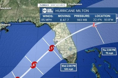
- Shear should cause Milton to weaken as it approaches the state. Still, Cat 3 is likely when it makes landfall.
- Where? Area between Sarasota and Hernando County appear most likely. Again, the exact point of landfall is unpredictable. Wobbles will also happen. The point of landfall and South will see the worst of it.
- Surge values of 8-12 feet are likely at landfall near the eye. Winds near the eye will be 100-120. Hurricane force winds will probably extend about 45 miles out.
- Widespread power outages expected. Never use a generator IN your home or garage.
- Milton will cross the state and bring hurricane conditions to inland areas including Polk County and Orlando.
- If you are in a mandatory evacuation zone, do so.
- If the storm slows down its forward speed, there IS the opportunity for additional weakening. There is always hope. But the reality is chances are high part of the Bay Area will see major hurricane impacts and a direct hit.
- Unfortunately, this storm is the real deal. The one we always knew was possible, but dreaded even thinking about it. So, now is the time to act. You still have 1 1/2 days. Follow evacuation warnings. Make your final preps.
- On a personal note, I know how scared and anxious people are. We should be. This storm is a beast. We need to work as a team to get through this. Storms can bring the best out in people. Neighbors helping neighbors. It's the only way. Our team will be here 24/7 to get you as much information as possible to help keep you and your family safe. Let's do this... TOGETHER. #FloridaStrong
- Water shutoff to the islands will happen tomorrow (Tuesday, 10-8) at 10am. This will be a bit different than Helene as it will happen earlier to ensure our infrastructure remains intact and to salvage our lift stations. Also, the water will be completely shut off. There will be no 20% flow.
- Power will be shut off Tuesday night when first responders leave the island
- MCAW Transit: Transport from the islands to shelters will start at 2pm and occur on the hour until nightfall. Pickup location: CVS, 611 Manatee Ave, Holmes Beach, FL 34217. Pickup will resume Tuesday morning at 8 am.
- Please note that the only emergency shelters opening in Manatee County today (Monday, October 7) at 2 p.m. are as follows:
- Mills Elementary School, 7200 69th St. E., Palmetto
- Miller Elementary School, 601 43rd St. W., Bradenton
- Myakka Elementary School, 37205 Manatee Ave., Myakka City
- Manatee County has issued a MANDATORY EVACUATION ORDER beginning at 2 p.m. tomorrow, Monday, Oct. 7 for Levels A and B. This includes all of Anna Maria Island, Cortez, Perico Island, Flamingo Cay, RVs, mobile homes, and some low-lying areas of Manatee County.
- For additional storm-related information, please go to mymanatee.org/storm
- Tampa International Airport will suspend operations beginning at 9 a.m. Tuesday and stay closed "until it can assess any damage after the storm," airport officials said.
- The St. Pete-Clearwater International Airport, just outside of Tampa, Florida, will close at 12:30 p.m. Tuesday and stay shut on Wednesday and Thursday.
- SRQ/Bradenton International Airport will close at 4 p.m. Tuesday, October 8th due to Hurricane Milton and will reopen once safe to do so. Please contact your airline directly regarding flight status. Stay tuned to our social media for further updates.
Hurricane Milton Information as of Sunday 10/6/2024 at 5PM:
AMI Chamber Sunday Update: “Our intent is to not allow in sight-seers, party goers and looters and those who simply have no business or purpose in coming to our city at this time of emergency preparation.”
Manatee County Sunday Update:
- Manatee County has issued a MANDATORY EVACUATION ORDER beginning at 2 p.m. tomorrow, Monday, Oct. 7 for Levels A and B. This includes all of Anna Maria Island, Cortez, Perico Island, Flamingo Cay, RVs, mobile homes, and some low-lying areas of Manatee County. PLEASE HEED THIS WARNING AND LEAVE!
- Manatee County Schools CLOSED Mon-Wed OCT 7-9th due to Hurricane Milton
IREV UPDATE - Based on the emails from today to our staff, I need to reiterate that our office is CLOSED, our team is not on island, and not available today. This week we hope to have a few managers signed in and working remotely for emergencies as they can. Yes, of course, we want to help. Unfortunately, for the first time since I can remember, we physically can't. Please refrain from reaching out to our team with requests during this time. The amount of emails from owners with property requests that our team can't possibly handle right now is overwhelming. Most of our team is traveling and preparing for this storm before it arrives in full force on WED. We are already dealing with lots of rain, gas storages, limited groceries, crazy traffic, full hotels, and panic throughout the surrounding areas. Your patience and understanding during this time are appreciated. We will hit the ground running once this is over and our team can return to work.


Quick Links
Contact Us
Stay In Touch
Copyright © 2025 Island Real Estate. All Rights Reserved. Web Design by InterCoastal Net Designs